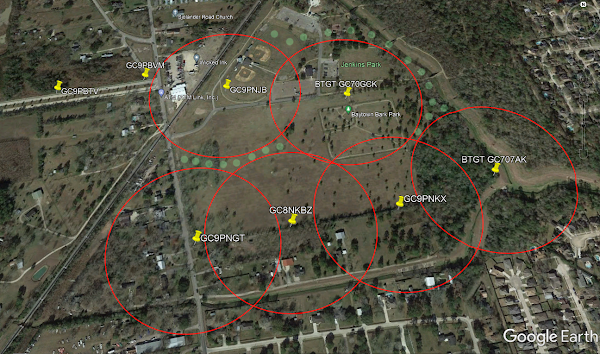
BB's Primer: Using Google Earth to accurately hide caches. Here is a graphic showing the actual location of caches in Jenkins Park in Baytown. I use this method to lay out an area to get the maximum allowable caches. Note: You cannot use Google Earth Geocache Viewer to determine where the actual cache is located.
Note: Shut off the optional Geocaching Google Earth Viewer, because it is inaccurate other than showing a cache is nearby.Copy the coordinates from the GC page and using GE, place a pin where the actual location is and rename it with the GC number. After all the caches are located and tagged, use the ruler or circle tool at the top of the page to measure in excess of 528 feet to determine if there is room for another cache.
This method will allow you to check your real coordinates when you hide a cache if you can identify the location with an aerial view and allow you to hide more caches in, say, a cemetery or a park. Why hide one when you can hide 2 or more?
On another note, you should make it a habit to check your coords on GE to be sure the cache is where you say it is.

Google Earth Pro's drawing tools do not include an easy way to draw accurate circles. But, the ruler/measuring tool does let you measure circular areas and save them as KML, so you can do the following to draw a circle:
Open measuring tool (ruler icon on toolbar, or Tools menu > Ruler)
In Ruler window, select the "Circle" tab
Select the units you want to measure the radius in (eg: feet)
Click (click, don't drag) on the map at the center point of your circle (Park-Cemetery)
Move your mouse until the circle radius is the distance you want (eg: 540 feet to be safe)
Click the map again to complete the circle
In the Ruler window, click the "Save" button
In the "New Path" window which appears, give it a name and click "Ok" button
Find your circle in the Places panel!
Here is an example of Jenkins Park with existing caches. The pale green dots are the only place a new geocache can be placed.
Baytown, Texas - Baytown Geotour GT7A


