Showing posts with label alligators. Show all posts

Sunday, November 22, 2015

Rating a cache’s difficulty/terrain primer


Rating a cache’s difficulty/terrain primer
By Bert Marshall (BaytownBert)
Southeast Texas Representative Texas Geocaching Association

This is a difficult subject (get it?) because the degree of effort is based on our own personal experience.  A newbie will almost always rate their first caches too high. As an example, I’ve seen a light pole cache rated a 3/2 and the first time I found one, it was every bit of that.  I guess it took me 30 minutes to find it looking everywhere but there.

Groundspeak, the parent organization of geocaching.com has specific guidelines for rating a cache’s D/T difficulty located here:  https://support.groundspeak.com/index.php?pg=kb.page&id=82

Based on these guidelines about 90% of all caches located in the Houston area are over-rated… but, let’s take into consideration some other factors not listed to possibly justify our ratings.  First there are our high temperatures and soaking humidity.  A 3 difficulty here in July means a 2+ mile hike one way with moderate elevation changes and significant overgrowth.

Going after this lone cache may just be the only thing you do that day and I’m not exaggerating.  We are home to the Big Thicket of Texas and it makes the Georgia woods of the Walking Dead look like an expressway in some cases.  A pair of machetes working in tandem means you can tunnel through at about 2 feet per minute, as we experienced in August of 2014 five miles north of my house.

The terrain was mildly flat and by all appearances a 2 at best, but with the oppressive heat and the thorns, it bumped up both D/T ratings considerably.  The particular cache our intrepid group of 18 went after is “Baytown Bert’s a crying GC3B8ZZ” and 3 other caches.  The distance for all 4 wasn’t too extreme, but we all made the 5 mile round trip cut to pieces and exhausted.  We were done for the day. 

Now, if these 4 caches were located in most sections of wooded area, they could be 2.5/3 geocaches.  However, in this section of heavy thorns, each foot you go is by force and these 4 have very high D/T ratings you would have to experience to believe they are realistic.  The first one is 18 feet up a limbless tree in fact and there is a fake human skeleton lying at the base of the tree.

Another item to note is this is semi-swampy and here in East Texas this means feral hogs, coyotes, alligators, banana spiders, and venomous snakes and with our vanishing wooded areas, they are heavily populated.  In Anahuac, Texas I drove down a dirt road and stopped at a historic marker, as my Bride and I walked up to it, a huge alligator blasted off and into the trees and water behind it.  I can’t say which of was the most scared.

I marvel at the terrain ratings I see in the mountains and other places and have often thought about ours in comparison.  My geocaching friend Hans ter Beek (Dhaulaghiri) is from the Netherlands and has spent an extensive amount of time geocaching here and he can tell you how tough this area can be and he has the scars to prove it as do we all.  My friend Barbara Rush (barbara2015) all but poked her eye out the other night, geocaching near Wharton, Texas and she was in a city park!

In summary, what I usually do when I am looking at a geocache is see the experience of the hider.  If they are a veteran, I pretty much believe what I read.  When it comes to setting the D/T of a cache I am hiding, I use my personal knowledge of the area and how evil it is to set the ratings.

Now after mentioning an “evil hide” I have to define it.  A nano or bison in 17 acres of bamboo is not an evil hide.  It’s a mean hide and I hate them.  An evil hide is one that is in plain site, but other cachers do not recognize it.  That sentence pretty much sums it up nicely.  Remember that geocaching is a game and that the difficulty and terrain ratings especially should be taken seriously if you are physically challenged.

Each year we do a 11-14 mile hike through the Piney Woods of East Texas and inevitably people will post intent to do it, when wisdom should tell them it is a bad idea.  If you want to do a cache or attend an event that is physically exhausting, talk to people who have done it first, or start hitting the track and treadmill.

Thursday, October 31, 2013

Baytown Nov 2nd Nurture Nature Festival!

 
 Starting at 10 am!
Friends of Brazoria Refuges “Butterfly Encounter”
Challenger Seven Learning Center
Jesse Jones Park and Nature Center
Texas Crawdads
Texas Snakes and More
Friends of Cedar Bayou
Houston Geocaching
Friends of Anahuac Refuge
John C. Freeman Weather Museum
Texans Together (San Jacinto River Coalition)
Texas Parks and Wildlife Angler Education
Texas Parks and Wildlife Archery
The Big Buzz Theory
Texas Kayak Fishermen
Texas Marine Mammal Stranding Network
Artist Boat
Texas A&M University at Galveston Sea Camp (Whoopp!!)
… and of course, the Eddie V. Gray Wetlands Education Center

Activities will include:

Young Audiences Nature Screenprinting
Marine Mural Painting (for the kids to paint)
Watering Hole Golf
Coastal Dinosaur Dig
Face Painting
Rock Wall
Huge Alligator Inflatable
Caterpillar Inflatable for the little ones
Obstacle Course
Prairie Seed Cups
Feather Find Bird I.D.
Catfish Fishing Pond
TPWD Take Me Fishing Trailer
Backyard Bass

Creole Kitchen will be on hand with their delicious catfish, shrimp, hotdogs and funnel cakes.

Stage Shows shouldn’t be missed either…

10:00 Texas Snakes and More
11:00 Friends of Brazoria Refuges Birds of Prey
12:00 Crocodile Encounter
1:00 Big Buzz Theory
2:00 Texas Snakes and More
3:00 Crocodile Encounter

Did I mention it’s all FREE? Please feel free to share this with your friends…. The more the merrier at a festival!!

Hope to see you Saturday!!
Baytown Nature Center
6213 Bayway Drive

Thursday, June 07, 2012

Fun In The Sun Baytown Texas

My bride and I loaded up my awesome 2011 Cosmos Blue Jeep JKU Sport and our doggies for a day of adventure and headed east on I-10 for Anahuac, Texas - which spell check identified as Nahuatl, which I suspect was the original language over there.  I know it is in Channelview.  We stopped at the entrance to the Wallisville Lake Project to grab a geocache (GC36NMH), but it was in pieces.  I logged it as a find and alerted the cache owners, TxDwight and TxJoAnn56.

We briefly perused the fruit stand at I-10 and FM563, but decided we would buy from the other stand at High Island, later in the day.  We decided to make another stop at the Jackson Cemetery in Anahuac, as there is a geocache there also, called "Thriller" (GC33KBD). 
My bride is a descendant of the Barbers and the Barrows and we found a goodly number of gravestones of a branch of the Barrow family.

While I searched for the tiny geocache we let the dogs explore and my bride looked for kin folk's grave stones.  If you are interested in learning about geocaching, the Baytown area has over 300 "caches" hidden and the number is growing every day.  It's a wonderful family and kid-friendly activity and will take you to obscure parks, cemetery's and generally get a person off the couch.
A branch of the Barrow Family are buried at the Jackson Cemetery in Anahuac, Texas

When we returned home, I went on the Internet to ancestry.com and could not link these folks with my wife's side of the family.  She is a direct descendant of Daniel Barrow and Ruby Amanda Barber and not this line. I photographed the headstones and submitted the pictures on findagrave.com for those who research this kind of stuff.  Its actually very popular and my brother TJ Bustem and sister Connie Byrd are heavily involved.
I call my Jeep Wrangler "tha Choppa" as it takes me anywhere I want to go, like a helicopter. "Get to the Choppa!"
We headed for a hike and a drive through the Anahuac National Wildlife Refuge to see if we could see some gators, but it was already very hot and we were unsuccessful. If you want to see wildlife, I advise going 60 miles south to Brazos Bend State Park instead.
At the Anahuac National Wildlife Refuge, we walked the boardwalk.


The last time I was down on this beach and what is left of SH-87, was about 10 years ago with the Baytown Chapter of the TX4X4 Cyber Club, now defunct, with the Boyd brothers, Bruce and Marshal.  Bruce was the President of our chapter and was tragically killed in a motorcycle accident on SH-146 in late 2003.  I haven't seen Marshal in a long time, although I talked to Bruce's wife the other day.  We led a group of over 120 Jeeps and 4-wheel drive trucks to Sabine Pass over the destroyed road.  The man at the fruit stand remembered the event.  I turned leadership of the whole club, which I founded, over to someone else and it is now called TX4WD.
The 25 mile stretch of road-beach between High Island and Sabine Pass.
The tide was in, along with a heavy stinky kelp deposit, which ran for miles.  The coastline is replete with trash and plastic and looks terrible, but this stretch of the coastline has never been pretty to me and others.  Hurricane Ike rearranged it considerably and the state has cut an alternate path inland, which due to the debris and oil-laden sand on the coast, forced us up onto it.  It's still very much a 4-wheel drive trail though, so beware if you think you can do it in your Zephyr.  We had a Chevy truck follow us for about 4 slow miles before they finally decided it was too risky and turned back.  Charles Goss and I rescued a man and his truck here one time who had been stuck for 18 hours.
Just for fun I drove up on a fallen log.
If I was going to "wheel" this beach, I would have aired my tires down and disconnected my sway-bars, but we were the Lone Ranger out here and it is never a good idea to wheel alone.  There are still plenty of obstacles, logs, giant chunks of asphalt, boggy quicksand, and debris to "crawl" over though - just don't do it alone.  My next beach run will be down south to Matagorda and 30 miles of pretty danged good beach.  The best though are North and South Padre Island.  I call this stretch of beach we are on, HISP.  High Island to Sabine Pass and it is pretty much boring and ugly, but in Texas, where most everything is private property, a person has to go to what is available if they want to test their machines against the terrain.

Saturday, February 04, 2012

Day Trip to Brazos Bend State Park

I don't even know where to begin. My Bride and I have decided we are going to start spending a lot more time together doing things we should have never stopped doing. Make sense? This does not include watching American idol while holding hands and singing kum-by-uh, or whatever that song was called.

I have a Jeep, kayak, and mountain bikes. We have a 9X17 foot tent and camp stove. I have 3 GPSr units. Heckfire, we can go and see and do. All we have to do…is do. This past Thursday, I took my newly acquired $70 Texas Park pass to Brazos Bend State Park with my bride and a protein-lovers picnic lunch and rode the trails. Well, we tried to ride the trails. More on that in a minute.
I loaded the geocaches in the park into my Garmin Oregon 450 and with my Bride's blessing, found 16 and all 16 were off the trail in the woods. To put it bluntly, I earned each one of them. She even came with me a few times and made the profound observation of: "I just don't see the fascination." I answered with, "Hey! There's another one 489 feet that way!"
You can tell by the photographs that I enjoyed each and every cache I found. The last 5 years I've been going to this park it's been so dry, it looked almost like the park was dying, but not this past Thursday. the trails I've hiked on foot were muddy and we rode, or tried to ride up the Big Creek Loop Trail only to have the brake calipers get clogged with mud, small rocks, and leaves.


We had to stop many times while I cleaned them off enough to ride. It was cloudy and a bit rainy, but we wouldn't let this stop us from enjoying the day. We saw many alligators and coots, egrets, herons, and some whistling ducks, but nothing like what will be in the park in 2 months. Brazos Bend State Park has more wildlife in it than you will see the rest of the year any place else.

We chatted with a retired school teacher from Canada then ate cheese, apples, and peanuts to refresh ourselves. Then my bride led me on a 3 mile hike on the White Oak Trail! I grabbed as many geocaches along the way as was acceptable to her. Noting her patience was nearing an end; I finally gave in and just hiked.  What a great start for the years adventures. We have a 3 day camping reservation in April for Pedernales Falls State park, one of my favorite parks and I am anticipating a great time there as well.

See more of the PARK HERE!
http://www.tpwd.state.tx.us/spdest/findadest/parks/brazos_bend/

http://www.tpwd.state.tx.us/publications/pwdpubs/media/pwd_br_p4504_0110x.pdf

http://www.tpwd.state.tx.us/publications/pwdpubs/media/pwd_br_p4504_0110r.pdf

http://www.tpwd.state.tx.us/publications/pwdpubs/media/park_maps/pwd_mp_p4504_0110w.pdf 
.

Friday, April 15, 2011

Nawlin's in a Beignut Shell!

 .
My bride and I took a much needed break from our routines and spent 4 days in the French Quarter, in New Orleans and man, the food was crazy delicious!  Neither one of us is a nightlife person, so we did some tours, visited one of NO's famous graveyards, saw an IMAX, walked and walked and ate and ate.  Here are a few photos of our trip for your viewing pleasure.

My breakfast in New Orleans - biscuits, poached eggs, grits, gravy & chicken livers!  The Old coffee Pot restaurant! Delish!
BB and Living Statue "Femora" at Jackson Square in New Orleans
BB and the absolutely silent "Silver man". I dropped a buck in his bucket and posed. Even though I made small talk, he was totally mute. He looked like "Mr. Natural" to me, from the underground comics.
 BB at the tomb of the voodoo priestess Marie Laveau in St. Louis cemetery.  I didn't feel a dang thing.
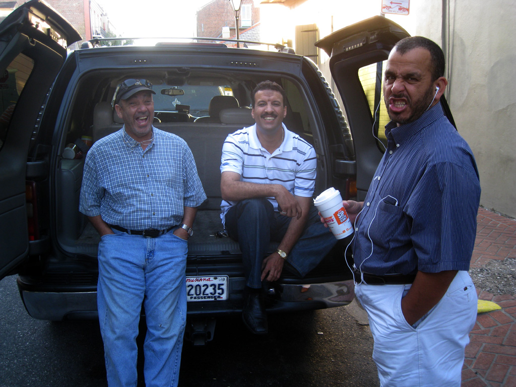
I ham it up with 3 Egyptian cabbies in front of hotel Maison Dupuy.  I asked them to smile and the fellow on the right made a funny noise instead.  We shared salted nuts and laughs.
 My bride and I took the Honey Island Swamp tour in Slidell.  The gators were delicious with mustard!!! I had 2 whole ones!
 At Cafe Fleur De Lis, I had the most delicious crawfish omelet.  Sounds disgusting, but just the opposite. My bride had the convention, but after tasting mine, she agreed it was a great combo. the price was very low also!
At the WW2 War Museum, my bride reads about the bloody battle of Biak,  where her humble Dad was stationed.  He told me one time that "the Japs strafed them every day".  Other than that, he never talked about it. R.I.P. Willard Reneau.
Go no further than Deanie's Seafood for awesome delectable shrimp and crawfish!  I had crawfish ettouffee and friend crawfish!
We went to the IMAX on the Mississippi river and listened to a  Hollywood movie star tell us how we are destroying all the water on earth!  I laughed all the way through it! Thank heaven for Hollywood!
BB over-doses on beignuts and tubas at Cafe Du Monde!
.
 

Monday, April 06, 2009

Trail, Road and Sky

Well, it’s been an active three days. Friday, my bride and I traveled to Brazos Bend State Park and hiked the many trails for four hours. It’s only the second time this year we’ve hiked together and it was very pleasant and fulfilling for both of us, at least it was for me.

When two people have been married for thirty-two years, it would appear walking a trail together would be status quo, but truth be told, many folks grow apart over the years and pursue their own agendas apart from their mate. My bride and I have walked many a mile together over the years, but seldom on long hikes, so this is new and exciting territory for us.

I’m pleased to say this was the second successful hike in the last two weeks for us and more are planned. In fact, I hope we hike many more miles in Brazos Bend SP in the next month so we can witness the American Alligator in rut. They are very active at this time and I am hoping we see a big male rumble and ripple the water as it calls females. If I can video it, I will be very pleased indeed.

My Lady is with me on this hiking business, as she knows it is a good thing. I am about three years from sixty and she is approaching fifty. What could be a better decision than walking the trails, looking at nature and getting exercise to boot? Speaking of boots, I ordered her a pair of Columbia Coremic Ridge hiker boots. The temerity! She reminded me this was very personal and I reminded her I knew it was.

I want my Bride to have all the comfort she can get on the trail, so I ordered her three pair of merino wool hiking socks also. Call it cheek if you like, but I call it protective compassion. Banging your feet on the trail bothers the feet and can ruin a hike and it doesn’t matter who you are or what skill level you have. Having good socks and boots makes a big difference in how long you can walk comfortably.

Saturday rolled around and I went down to Texas Avenue for the Bayshore Fine Rides car show in time to watch Mean Gene Kelton and his Diehard band. I had a good chat with former council member Sam Mahan and a couple of other folks, but the best visit was with Ken “the dauber” Pridgeon. Ken’s a local artist and a mover and shaker in the Baytown Art League. He was sitting at a table in front of the old Brunson Theater drumming up signatures to save the old building. Of course, I signed.

Sunday morning, I skipped Sunday School (again! – Lord forgive me!) and geared up for a ride out Beach City way. In my defense, this area is very hostile to cyclists, as there is very little shoulder on the roads and even less tolerance from cars drivers. It’s so bad out there that riding a bicycle is flat-out dangerous. The only safe time to take a long distance ride is on Sunday morning.

I left the house about 9am and made my way down the south side of Business 146 to Kilgore road. Old Kilgore is now new Kilgore and awesome cement. You would have to see it to appreciate how improved this road is. Passing Roseland Park on Texas Avenue, I peddled to Spur 55/Hwy 99 and crossed over Cedar Bayou, stopping to appreciate the view and look to see what changes have been made concerning the proposed Barge Terminal.

On West Bay road, I turned and rode towards the dump, which believe it or not is odorless and actually not a bad ride. Since it was Sunday, there was little traffic and I had the road to myself. The open road and big sky got me to thinking how much I liked wide open spaces. Trail, road and sky…and me. Just the way I like it.

I usually ride straight out Fisher Road to Tri-Cities Beach Road, but the wind was picking up and I knew I was going to be riding into it one way or the other and that long stretch out by Trinity Bay can be murder, so I elected to ride the opposite direction and have most of this wind at my back and then fight the head wind on the return down the five miles of Fisher Road.

What I experienced though was a bad crosswind on Tri-Cities and total frontage on Fisher. By the time I got to the Wesley Riggs Memorial on TriCities, I was pooped. I always stop and pay my respects to the fallen local hero PFC Wesley Riggs. He and his family payed the ultimate price in Iraqi Freedom and deserves a few minutes of reflection.

Needless to say, that ride into the 10-15 mph wind on Fisher road turned me into a grunting 56 year old man and I finally wheeled down my own street exhausted and once again fulfilled. I’ll do it again, but next time I’ll check the wind report, but the sum of all this is I got off the couch and did something outdoors.

Thursday, March 12, 2009

Banging my Foots on the Trail


I guess I’m the proverbial glutton for self-abuse. Only a week has gone by and I’ve went hiking again and I blasted off like I was a spring chicken after working a shift at the Chemical Plant that pays my bills.

I blame Brazos Bend State Park, its wildlife and the Staff that maintains this great Park for drawing me back so soon, plus the fact that American alligator breeding season is in full heat. If you want to see gators, now is the time to go where they live.

I made the hour and twenty minute drive from Baytown to the Needville, Texas State Park (BBSP) and pulled in the Ranger station right about 8am. I was greeted by a friendly Hispanic Ranger and I attempted in my meager Spanish to ask about mosquitoes. She instantly warmed up to me and told me in Spanish that zancudos were no problemos right now due to the dry weather.

I parked in the first lot, next to the bathroom facilities and made my way down the short Prairie Trail towards the 40 Acre Lake.

Right off the bat I noticed two large alligators lounging close to the bank. This was a big change from a week ago when the alligators were more sluggish. This morning they were alert and numerous times during the day I witnessed them sliding along or moving towards me as I walked the trails.

They tell me they’ve never had a serious incident in the park concerning alligators, but warning signs are posted and during breeding season, the gators move all over the place. This is important to note, as one could be directly on the trail, or lying beside it in deep grass. When in doubt, keep to the middle of the well-maintained trail.

Since the park was for the most part devoid of people and it was early morning, my head turned back and forth like a pendulum, as I walked, but I was confident and cool and I was steadily hiking, looking and taking photographs and videos to post on the web.

I was having the time of my life and the best part was I knew it as I was doing it.

All the State Parks have online maps and also in the park you are visiting. I grabbed one at the Ranger station and they are printed on 8X14 paper and quite rugged. Each time I’ve hiked, I used mine extensively (with sweaty hands) and they hold up very well.

This day I plotted what I figured to be about 12 miles, using a series of trails and visit part of the park I did not hike the week before. The only problem I encountered was getting from one trail to the next across the park and not having a to-scale map to gauge the distance. This hike grew as I walked it and even though I kept on a steady pace, it turned into a 14 miler by trails end.

I shot 11 videos for posting on youtube and if you subject yourself to them in the order I shot them by following my web pages, you will see how beat down I became by the last one. I had foolishly run out of water, even though I took what should have been enough, my feet were sore and I was dehydrated. Live and learn you say? Not likely, as this wasn’t my first rodeo…but, I am okay and next time I’ll bring a hydration pack instead of my lumber pack, which only carries 32ounces of water.

What got me down was the temperature and rising humidity. Up until then, I’ve been hiking with cool temperatures and 78 degrees while hiking 14 miles and carrying 20-pounds of gear multiplied the stress factor. That and the five and a half hours of strenuous hiking.

Anyway, my photos are posted here along with the many videos.

All feedback on http://www.youtube.com and ratings will be posted and appreciated.

Thursday, March 05, 2009

BB Hikes the Brazos Bend SP Trails


I’m fresh off the Pedernales Falls State Park camp-out; my coat still has the faint scent of wood smoke and I decided I just had to go check out another set of trails. I’ve got a fever and the only prescription is more trail-hiking, to plagiarize Christopher Walken’s famous line.

Now I have reservations for a 4 day campout at McKinney Falls State Park in three weeks and since there is a burn ban in effect there, I’m cancelling it and going back to Pedernales Falls, where they will let you have a campfire. Anyway, even though I have a trip planned, I still want to go hiking and I want to do it anytime I get the chance, so here is how it all went down this week.

Back about ten years ago, my bride and I drove through BBSP (Brazos Bend State Park) and basically stayed in the car and visited whatever was viewable from the front seat – hardly the best way to see nature and this was my meager memory of the Park. However, we now have the Internet at our fingertips and the great State of Texas’ website people have gone way out of their way to attract campers, hikers and day-trippers. Maps, photos, scads of information and even videos of the park grace their well-built web pages.

I downloaded a park map and a separate trail map of BBSP so I could plan out a good 10-mile hike and then I enlisted the fellowship of my son, Nick and nephew, Andy Tallant. These two mid-20’s fellows made for some good company and a lot of trail humor to boot and we all benefited from pounding our feet on the trails.

Now, I’m in Baytown and according to Google Maps, BBSP is about 70+ miles from my house, but Houston traffic had a tail-wind and we arrived exactly one hour after leaving the house. My goal was to arrive at 9am and we did. I stopped at the main gate and flashed my Texas State Park Pass ($60 once a year and well worth it), which allowed me and my trail mates free access, so to speak.

Nick, Andy and I wore semi-warm clothes, as it was 50-degrees F and both young men wore water bladder packs, as we wanted to make sure we did not get dehydrated. I wore my excellent High Sierra Ridgeline Lumbar / Waist Pack w/2 water bottles. I like to eat sunflower seeds when I hike and we each took a couple Nature Valley Sweet & Salty Nut granola bars for an energy fix. A 10 miler was planned and 2.5 mph is about all a person can do if stopping to “smell the roses”. Our hike took about 4.5 hours and we felt a bit pooped afterward and real hungry.

This Park is really an amazing place for wildlife viewing, more so than any place I’ve hiked. We saw many American alligators, a wide variety of waterfowl, logs loaded with turtles and even a river otter. The park is not a zoo by definition, but we were able to see such a wide variety of wildlife that it felt like we were observing tame animals. I had no idea we were in for such a visual treat. I’m used to seeing wildlife high-tail it for the horizon, not ignoring me and this was fantastic and really added to our outdoor experience.

Both of my trail companions remarked that this would be an excellent place to bring a lady friend instead of “just going to the movies”, or sitting in front of an Xbox 360. There are camp sites, screened shelters, excellent bathroom and shower facilities available and picnic areas for park visitors.

One two occasions, I peaked over an obstacle to spy the American bittern, the only time in my life that I have been this close to this normally secretive bird. Blue-wing teal swam in groups and alligators lounged along the trail – so beware. One time Nick spotted a large gator covered with green pollen, not 40 feet off the trail. While we looked at it, Andy spotted an even larger cousin right behind us, just 30 feet off the trail. The Park’s web site warns us 30 feet is as close as we dare to get to these large carnivorous lizards, as they can cover the first 30 feet of ground at 30 miles per hour.

Great park, great time and I will be going back in April during the alligator breeding season, so stay tuned. Here are my photos.

🇺🇲 BB's Uncensored Daily News Brief #609 10-26-26 #Alt-news

 ðŸ‡ºðŸ‡²  BB's Uncensored Daily News Brief #609 10-26-26 #Alt-news 🇺🇲 Use a search engine to investigate each headline via SOURCE cited (...